2,200 earthquakes in Iceland in 24 hours: What it means for the region
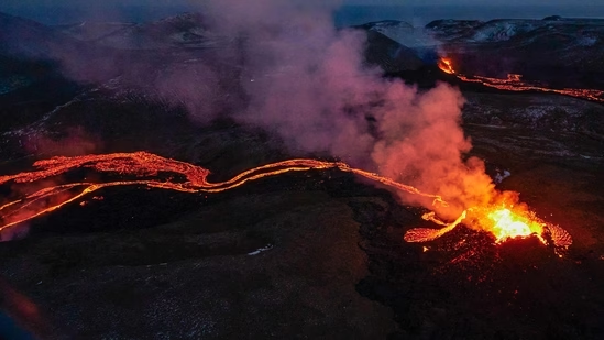
Almost 2,200 earthquakes were recorded in the area around Iceland's capital Reykjavik in the past 24 hours. The country's weather office warned that it is a signal that a volcanic eruption could be imminent.

What did Iceland's weather agency say?
The Icelandic Meteorological Office (IMO) said the tremors began around 4 pm beneath Mount Fagradalsfjall. The mountain sits atop a volcanic system where two eruptions have occurred in the past two years on the Reykjanes Peninsula- Iceland's southwestern tip.
"Around 2,200 earthquakes have been detected and the largest earthquakes have been felt in the Southwest part of Iceland," the agency said. More seismic activity was likely, it added.
Read more: Ukraine's Zelensky blames West: ‘I wanted our counteroffensive…’
What we know about the Iceland earthquakes?
Seven of the quakes had a magnitude over four- considered a light quake. The seismic activity resulted in the aviation alert being raised to "orange" from "green".
Why are earthquakes in Iceland worrying?
Iceland is Europe's biggest and most active volcanic region. The North Atlantic island straddles the Mid-Atlantic Ridge- separating the Eurasian and North American tectonic plates.
Has this happened before in Iceland?
In April 2010, 100,000 flights were cancelled, leaving more than 10 million travellers stranded, following the massive eruption of the Eyjafjallajokull volcano- the biggest air traffic disruption in peacetime until the Covid pandemic.
Lava spewed out near Mount Fagradalsfjall in both 2021 and 2022 as well.
Disclaimer: The copyright of this article belongs to the original author. Reposting this article is solely for the purpose of information dissemination and does not constitute any investment advice. If there is any infringement, please contact us immediately. We will make corrections or deletions as necessary. Thank you.
Title:2,200 earthquakes in Iceland in 24 hours: What it means for the region
Url:https://www.investsfocus.com


