Hurricane Beryl grows into ‘extremely dangerous’ Category 4 storm
Hurricane Beryl grew to an “extremely dangerous” Category 4 hurricane set to cause massive damage across the Caribbean’s Windward Islands late Sunday into Monday.
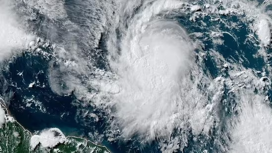
Beryl’s winds have reached 130 miles (209 kilometers) per hour, making it a major Category 4 hurricane as it churned westward toward islands including Barbados, St. Vincent and the Grenadines, and Grenada, the National Hurricane Center said in an 8 p.m. New York time advisory. Wind and heavy rain will spread across the islands overnight as Beryl approaches.
“Potentially catastrophic wind damage is expected where the eyewall or core of Beryl moves through portions of the Windward Islands, with the highest risk of the core in St. Vincent and the Grenadines and Grenada,” Philippe Papin, a hurricane specialist at the center, said in a forecast.
“A life-threatening storm surge will raise water levels as much as 6 to 9 feet above normal tide levels in the areas of onshore winds near where the eye makes landfall,” he said.
Beryl has exploded in strength since Saturday with its winds increasing by 50 mph in the last 24 hours, meaning it has met the criteria for a phenomenon known as rapid intensification. After Beryl crosses the Windward Islands, an arc-shaped chain in the eastern Caribbean, it will move through the sea potentially threatening Haiti, Jamaica, and the Cayman Islands through the week before possibly making landfall in Mexico on Friday.
Most computer models keep Beryl away from US offshore oil and gas operations in the Gulf of Mexico, but there is an outside chance the storm may threaten the region later this week.
A tropical depression, meanwhile, has formed in the Bay of Campeche off Tuxpan, Mexico, the hurricane center said. It may strengthen into Tropical Storm Chris overnight before it comes ashore.
What forecasters find alarming is that Beryl formed in an area of the Atlantic between the Caribbean and the Cabo Verde Islands in June. This stretch of ocean, called the main development region, doesn’t usually become active until late August.
An early start due to warm water and optimal conditions there portends future disasters, and the hurricane center is already tracking what may be the season’s next storm after Beryl, near Cabo Verde.
Before the six-month season started June 1, forecasters were already predicting the Atlantic would produce upwards of 20 or more storms, when an average year churns out 14.
Beryl is the farthest east a hurricane has formed in June and will be only the third powerful storm to track through the Caribbean before August since 1851, Phil Klotzbach, a hurricane researcher at Colorado State University, said in an email interview.
The records Beryl has shattered were set in 1933, when the fourth most active year in Atlantic also released the most energy, and 2005, which had the second highest number storms behind 2020.
“This isn’t a good sign for the upcoming season,” Klotzbach said.
Disclaimer: The copyright of this article belongs to the original author. Reposting this article is solely for the purpose of information dissemination and does not constitute any investment advice. If there is any infringement, please contact us immediately. We will make corrections or deletions as necessary. Thank you.
Title:Hurricane Beryl grows into ‘extremely dangerous’ Category 4 storm
Url:https://www.investsfocus.com