Hurricane Lee's path and timeline: Meteorologists project when and where the storm will hit
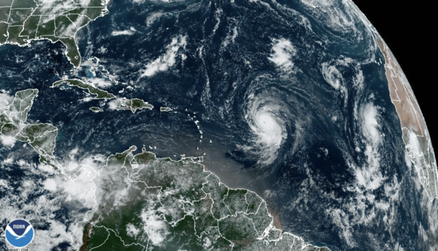
Hurricane Lee strengthened rapidly Thursday and developed into a major Category 4 storm, the National Hurricane Center said.
Lee strengthened from a tropical storm into a Category 1 hurricane on Wednesday, and by Thursday morning, it was a Category 2 with maximum sustained winds of about 105 miles per hour, with higher gusts. Within hours, it had grown to Category 4 with maximum sustained winds of 130 mph.
Lee intensified rapidly over the very warm waters of the Atlantic, and forecasters say it could reach Category 5 — a potentially "catastrophic" storm — as it continues churning along its path.
Lee was forecast to continue intensifying through Thursday night, with possible fluctuations in intensity after that, the NHC said in an advisory at 5 p.m. ET Thursday. "Lee is forecast to remain a powerful major hurricane well into next week," the center said.
Hurricane Lee spaghetti models
Spaghetti weather models, or spaghetti plots, are computer models showing the possible paths a storm may take as it develops. These models don't predict the impact or when a storm may hit, according to the Weather Channel, but focus on showing which areas might potentially be at risk.
Spaghetti models for Hurricane Lee mostly show the storm traveling over the ocean. Some paths would take the storm close to the Leeward Islands, which include the Virgin Islands, Anguilla, Saint Martin and Saint Kitts.
A spaghetti model for Lee created Wednesday morning, seen below, shows most projected paths curving northward and remaining out over the open Atlantic, but a few veer more to the west for a potential impact in the islands or along the U.S. Mid-Atlantic or New England coast late next week.
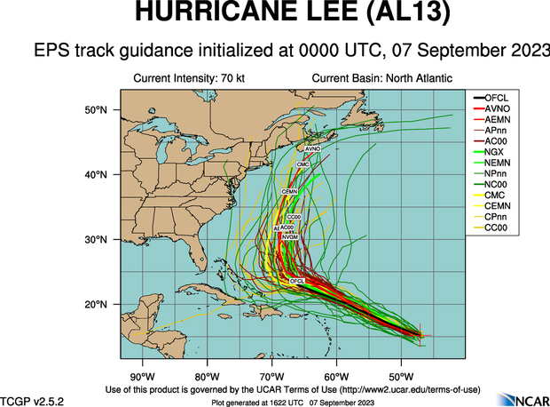
Another set was posted by The Weather Channel's Jim Cantore, who wrote: "Some solutions into late next week (shown below) are too close to ignore. Some don't touch land. This is all common with something in the 7-10 day away range."
Model ensemble blend look at #Lee next week. Some solutions into late next week (shown below) are too close to ignore. Some don't touch land. This is all common with something in the 7-10 day away range. Plus the simple fact that track errors go up rapidly after 5 days which… pic.twitter.com/KCbIHRnU2D
— Jim Cantore (@JimCantore) September 7, 2023
Where is Hurricane Lee heading?
Hurricane Lee is expected to pass near the northern Leeward Islands and Puerto Rico this weekend. The Leewards are a group of islands where the Caribbean Sea meets the western Atlantic Ocean.
As of 5 p.m. ET on Thursday, Lee was traveling west-northwest at 15 mph over the southern Atlantic Ocean. It was forecast to continue that movement for several days before "gradually slowing down its forward speed," the NHC said. Its center was about 780 miles east of the northern Leeward Islands.
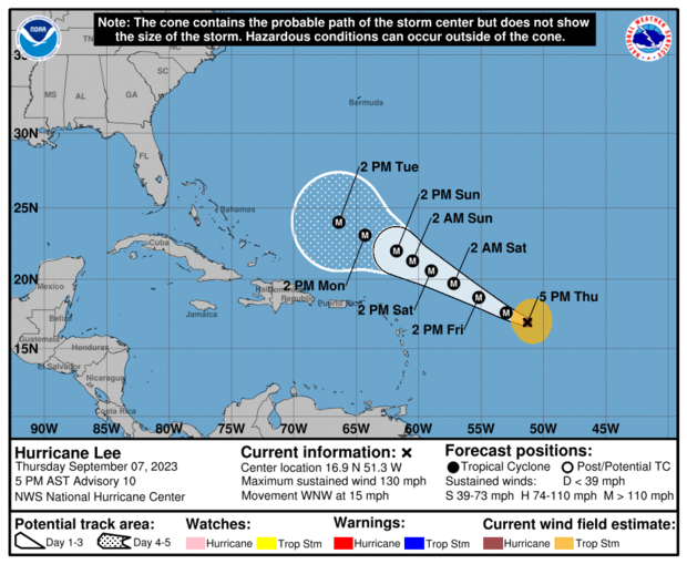
Large ocean swells are expected to reach the Lesser Antilles by Friday and the U.S. and British Virgin Islands, Puerto Rico, the Bahamas, Bermuda and Hispaniola by the weekend, the hurricane center said. The swells could cause life-threatening surf conditions and rip currents, and people in the area should keep an eye on local conditions before going in the ocean.
There are no coastal warnings or watches in effect at this time, the hurricane center said, but "interests in the northern Leeward Islands should monitor the progress of Lee."
- How do hurricanes get their names? A look at the naming process and 2023's full list of storms
Where will Hurricane Lee make landfall?
Right now, it's too early to say whether Hurricane Lee will make landfall, forecasters said.
Even though it will travel near the Leeward Islands, The Weather Channel reported that the "most probable scenario" is that the area will experience "a brush of gusty winds and showers to the northern Leeward Islands" as the storm tracks north.
However, forecasters said they "can't fully rule out a more southern track that takes Lee closer or directly through the islands with more serious impacts."
The longer range forecast is uncertain, but meteorologists will be watching to see if Lee starts steering towards the U.S. mainland or remains on a path over open ocean.
Is Hurricane Lee going to hit Florida?
Hurricane Lee is not currently forecast to impact Florida, CBS Miami reported. CBS Miami chief meteorologist and hurricane specialist Ivan Cabrera Lee said the storm system is expected to turn to the north and away from the southeastern U.S. coast, but weather experts will continue to monitor its progress and track it closely.
Florida is recovering from Hurricane Idalia, which made landfall along the Gulf Coast last Wednesday and left a trail of damage across the Big Bend region — the area where the Florida peninsula meets the panhandle. The storm caused severe flooding in Florida and other states including Georgia, South Carolina and North Carolina, before moving out to sea. Several deaths have been attributed to the storm, and the financial toll of the hurricane could reach $20 billion, CBS News previously reported.
Will Hurricane Lee hit the Carolinas?
Some models show the hurricane passing close to the Carolina coast, but according to CBS affiliate WNCN in Raleigh-Durham, there are "no indicators this storm will directly impact North Carolina" at this time.
Forecasters at the station said that "steering flows should take Hurricane Lee away from the East Coast," with the storm expected to curve north, then northeast.
Will Hurricane Lee hit the Northeast?
CBS New York reports the forecast models have been going back and forth on the track of the storm — on Sunday night, they were suggesting a landfall in the Mid-Atlantic region, then on Monday, going out to sea. As of Wednesday, the track was closer to the East Coast.
The ECMWF, or European model, has Lee staying out to sea and not making a direct landfall, but coming very close to the U.S. mainland. Meanwhile, the GFS, or American model, has Lee scraping Cape Cod, and then heading into the Canadian Maritimes.
"At this time, most longer range models do NOT have Lee making landfall anywhere on the East Coast, including New England," CBS Boston reports.
However, it adds, "This is a very long-range forecast and LOTS can and will change in the coming days. So, by no means should anyone on the East Coast (or in New England) write this storm off and put your guard down."
Meteorologists expect to get a clearer picture of the storm's likely path as it continues to develop in the coming days.
- In:
- Atlantic Hurricane Season
- Oceans
- Tropical Storm
- Florida
- Hurricane
- Atlantic Ocean

Kerry Breen is a news editor and reporter for CBS News. Her reporting focuses on current events, breaking news and substance use.
Disclaimer: The copyright of this article belongs to the original author. Reposting this article is solely for the purpose of information dissemination and does not constitute any investment advice. If there is any infringement, please contact us immediately. We will make corrections or deletions as necessary. Thank you.
Title:Hurricane Lee's path and timeline: Meteorologists project when and where the storm will hit
Url:https://www.investsfocus.com